Sunday 25 September 2011

Des Prairies river canoeing from Montreal island

The Des Prairies river (Plains river) flows between Montreal and Laval islands. Montreal and Laval islands are the two largest islands of the Hochelaga archipelago (over 200 islands) created by the mixing of two great rivers that are the Ottawa and the St-Lawrence rivers. The western part of the Des Prairies river has honest currents with small stretches of white waters. Someone can do a fair distance upstream with a canoe that has a saddle or strapping gears. Thats what I did today which was september 25th. Canoe landing was possible from Roxboro island in the western part of Montreal Island. To get there take the Boulevard des Sources exit from highway 40 and drive north up to Gouin boulevard. Then turn right on Gouin then left 2-3 streets later on 5e Av. (5th avenue). Go to the end of 5e av. for parking. Parking allowed all day during weekend days but only from 9:00 am to 4:00 pm during week days. Here are some pictures from this canoe day.


Above: Des Prairies river section described in this blog. Color coded map is from canoeing association Fédération Québécoise du Canot-Camping


Above: the entrance of Roxboro island.


Above: you have to cross Roxboro island to reach the Des Prairies river. Portage from start of Roxboro island to the river is maybe 100 to 200 m. Landing of canoe directly on the left of the bridge will bring you to the river but in low water like today I needed to get out of the canoe 2-3 times to get over obstacles. Beware for your  white clothes, its muddy. Distance from bridge by canoe around 200 m.


Above: Upstream view of the Des Prairies river from Roxboro island. The Laval side in this area (across) is very residential while the Montreal island side in the Roxboro area (this side) is better conserved. A lot of ducks and geese observed on the Montreal island side. Went canoeing upstream. First stop was at the ridge where there is a bit of white water (at the end of the picture).


Above: The ridge goes from the Montreal island side to almost the other side (in Laval). White water at the end of the ridge towards Laval island is perfect for someone that wants to get familiar with wave surfing.


Above: Downstream view from the ridge. Mont-Royal in sight. Downtown Montreal is behind Mont-Royal in this picture.


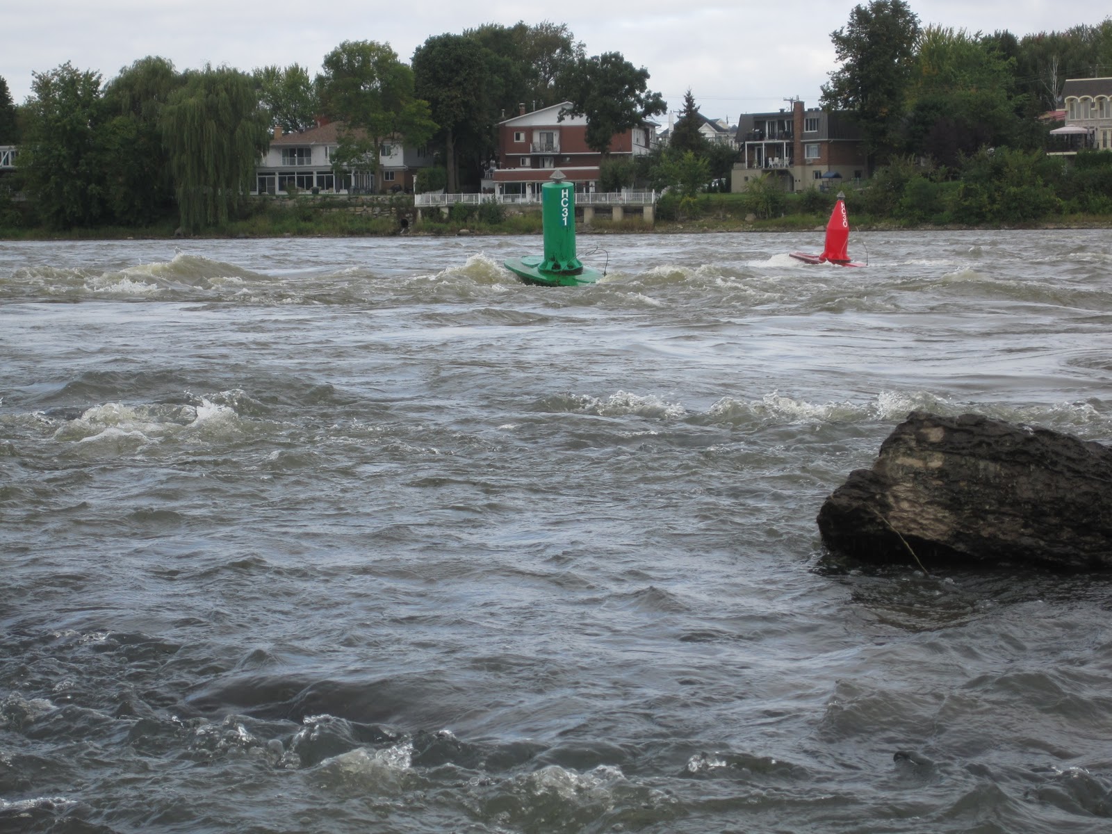
Above: The Des Prairies river waterway passes on the right side of the ridge when coming upstream.


Above: To get more upstream on the river my paddling skills dont allow me to use the waterway like these guys (I am challenging anyone to try). Crossing the ridge with my feet in the water fairly easy. Paddling on the left side after crossing the ridge is much more easy to get more upstream.


Above: Train bridge crossing from Montreal island to Bigras island. This bridge is around 1 km upstream the ridge.


Above: Train bridge crossing to Bigras island again.


Above: Bridge pillars always a nice spot to rest when going upstream. Car bridge leading to Verte island (Green island). Went upstream toward that bridge and further up.


Above: Several houses around the islands in this area have their waterfront like fortress to protect their houses from spring high waters.


Above: The Des Prairies river is probably the biggest hydroplane hub in Quebec. When hanging on this river, you are almost always sure to see one either landing, taking off or being parked. This parked one was observed between Bizard and Bigras island. Thats the furthest upstream I went on the river.

Sunday 4 September 2011

Canoeing along the Long-Sault islands in Ontario

The Long-Sault islands are accessible by a parkway that crosses every islands sitting on the St-Lawrence river in a string-like fasion. It takes around 1 hr 15 min by car to get there from Montreal in the south-west direction. The parkway goes from Long-Sault to Ingelside on the north shore of the St-Lawrence river and crosses a dozen islands. The islands are part of some sort of a park (there is an entry fee) and allow all kinds of water sports including fishing and allow camping. Canoe landing is possible all over the islands. Long-Sault stands for Long Rapids but dont look for them they are gone. I think they got flooded when the St-Lawrence seaway was built in 1950s when the dam located in Cornwall was built. Some villages were also flooded and sacrificed for the seaway and that dramatic event is still palpable in this area (theatre events remembering the events, routes that goes directly into the St-Lawrence river, local people talking still about it etc). The islands are great for carp fishing  and are internationally known by the carp fishing community. It is possible to see schools of big carps hanging in shallow water in bays around the islands. Beware of islands sitting outside the Long-Sault string, they may be part of USA and if you decide to canoe around them you will be illegally crossing the US border (thats exactly what I did ounce). Contrary to Quebec, the section of the St-Lawrence river that crosses Ontario is divided in two with the US. Here are some pictures.


Above: One of several spots to land canoe on the Long-Sault islands.


Above: canadian geese are common on the Long-Sault islands.


Above: it is possible to rest on several different spots on the Long-Sault islands.


Above: no, these are not apple trees but hawthorns. Given there sizes they must be very old.


Above: typical Long-Sault island shallow water bay. If you canoe in these bay and you ear feet walking in the water but you dont see any human being: its a carp. If you ear some sucking noise but dont see anyone: its a carp sucking on water plants roots.


Above: wild lilies can be observed in shallow water of shady bays. These were observed from Croil island wich sits across the most western located of Long-Sault islands. These lilies could have put us into trouble since Croil island is on the US side of the St-Lawrence river. Croil island smells very good in june and nothing stop its scents to cross illegally into the Canadian side.