The Lachine rapids connects the Lac St-Louis enlargement that is upstream downtown Montreal to the Lasalle borough that is just west of downtown Montreal (see also Part II blog in August 2011 folder) . It is a huge area of nasty current and of nasty R1-R3. Every level canoeist can find something for himself. But beware of over enthusiasm these rapids are meant to be respected. The debit of the St-Lawrance river around that area was more or less 10 000 m3/s. I am just starting to explore that area so I decided to start with the end of the rapids in LaSalle borough just to get a taste of what these rapids are. The LaSalle borough has a huge linear park on the St-Lawrence river waterfront so there are plenty of spots to land a canoe from the LaSalle boulevard. You cannot land your canoe upstream of the islands seen on the picture below because that section is a migratory bird sanctuary. Sorry for the bad quality of the pictures in this blog, I touched something on my Canon Powershot S3 and I am to retarded to figure out what happened.

Picture above: here is the view someone can have from the LaSalle borough linear park were the Lachine rapids ends. Landing of canoe possible anywhere on the shore but not more upstream on the right (not seen on picture) because of the presence of a migratory bird sanctuary. Put long sleeve since I got poison Ivy ounce (1 out of 10 times maybe). On the other side on the picture is Heron Island, one of the biggest Bleu Heron nesting area in North America. On the other side of Heron Island flows also rapids as large as the ones seen on this picture. To get access to that section someone can go at the park in the city of St-Catherine on the other side of the St-Lawrence river.

Picture above: LaSalle linear park and LaSalle boulevard were you can park. From downtown Montreal the easiest way to get there is to take Atwater street all the way south to the end of the street, than Lasalle boulevard on your right. Pass a marina, a swinming pool and other facilities. After that you should see a stretch on the linear park without facilities and then an isolated ancient stoned mansion sitting in the park. I parked near that mansion.
Picture above: I went canoeing upstream. Its been 3-4 time now that I want to reach the last island seen on the picture on the right. That is were the biggest waves are and it would make amazing pictures. Waves there dont appear that big from this picture because of the distance, but believe me with binocular someone can appreciate how amazing that section is in terms of how huge these waves are. But I was not able to reach that island again this time because the level of the water was too high. I still managed to go upstream to the biggest island in the middle of the picture. It is possible to manage going upstream because of the numerous obstacle that are disseminated around that allow someone to hop from obstacle to obstacle.
Here are some pictures below I managed to take while resting being obstacles while paddling upstream. Again sorry for the poor quality of the pictures due to something I touched on my Canon Powershot S3 that I cant figure out.


Picture above: there are houses on Heron Island reachable by boat only.


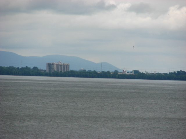
Mont St-Hilaire in sight. A cargo bypassing the Lachine Rapids can be guessed behind the tree line on the picture on the right of the building. This section were the cargo can be observed is part of the St-Lawrence seaway that allow cargo to reach the great lakes. Before the creation of the St-Lawrence seaway in the 1950s (the US Army Corp of Engineers were involved in its creation) every boat going upstream the St-Lawrence river could not go more upstream than Montreal because of the Lachine Rapids. The engineering behind the creation of St-lawrence seaway (the Lachines rapids is only one part of it) is apparently an incredible accomplishment I was told.

The Champlain bridge seen on the picture leads to downtown Montreal from the south shore.

Picture above: The point on the right is part of the above mentioned bird sanctuary. Try not to approach it even if you see people around. People can walk around the sanctuary but can not canoe around it !!!! There are also always people fishing on this point. The foggy line on the picture is due to the heavy white water (the roaring sound it makes is very impressive also). On a foggy morning that is the last place were the fog dissipates.

Picture above: Surreal effect due to geography and power of current. There are two currents observable here at 90 degree from one another. The current closer to the camera is perpendicular to the current seen the furthest from the camera which flows from right to left.

Picture above: Here is a question to the geologists: how to explain that the rocks found in the Lachine rapids look alike rocks found around and on top of Mont-Royal in downtown Montreal ?
No comments:
Post a Comment