Above: Canoe landing spot is circled. Colored code map is from canoeing association Fédération Québécoise de Canot-Camping.
Chambly bassin on the Richelieu river. The Richelieu river is a primary tributary of the St-Lawrence river. The mountain on the picture is Mont-St-Hilaire. One of the 6-7 isolated mountains on the Montreal south shore area. There are nice apple orchards on Mont St-Hilaire lower slopes.
Thats the Chambly stronghold. On the picture, current goes from left to right and stops in Chambly bassin that starts on the right side of the stronghold. Old Chambly and water front is on the right side of the bassin as well. Its possible to go counter current when paddling beside the concrete wall on the left side of the stronghold. (see below)
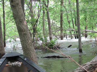
Was able to paddle upstream up to the trees beside the wall. Then cross facing the current toward the other side were there is a line of trees on the left. That is were the flooded islands are.

Big obstacle like this tree were all over the flooded islands to allow for resting ounce in a while.
The lines on the tree tells us the water level at one point this spring was maybe a foot higher. Amazing.
Paddling between trees was such a cool experience.
Thats the most upstream I was able to go. White water section on the picture dont seem that bad from this picture but believe me there were 6-8 feet high waves there. I guess that would have been a real turn on for wave surfers or kayak surfers.
That is another section I was capable to paddle upstream thanks to the irregularities of the shore side of this island.
There are a few country houses on the islands built on pillars to avoid spring high waters. But this year high waters are so exceptional that these country houses are still damaged. They will need higher and stronger pillars.
This is not flash flooding. Its been like this from april to early june because of an unusual rainy spring. White water in trees is a first to me. One of the most fun canoe ride ever.
This is what someone could experience every early april. It is kind of neat to experience it in june with leaves on the trees and in short and t-shirt.


This comment has been removed by the author.
ReplyDeletehello, my name is dick benjamin and i'm from New york. i and some friends are thinking about paddling the Richelieu from Lake Champlain to some point down (or up stream). can you suggest any reading materials, websites, whatever that would help us plan such a trip ?
ReplyDeletethanks in advance.
Hi benjy,
ReplyDeleteCanoeing the richelieu river from Champlain lake sounds like an interesting idea. The Richelieu valley is a mixture of agricultural / semi-wild / urban. Small-medium size cities that the Richelieu crosses (like St-Jean sur Richelieu, Chambly, Beloeil) all have a nice waterfront that correspond historically to their old versions that are nicely revitalized with restaurants, bistros, municipal parks etc. I think the most challenging will be to find camping spots. I dont recall any official camping spots but I am not familiar with the whole river, only the Chambly area. You can call toll free at BonjourQuebec and ask whaterever question is needed. Its a Quebec tourism info. hub. and people are pretty good at finding specifics for tourists. Another thing to consider are dams. I am not sure how many there are on the Richelieu (2-3 maybe)
and how easy they would be to portage. There is one upstream Chambly (see picture on my blog). Between St-Jean and Chambly there is rapids that seem in general easy to paddle but a section below the dam at Chambly (see picture and comment on my blog). There are locks between St-Jean and Chambly to allow boats to bypass these rapids. You can have more info. somewhere from a Canadian federal web site concerning these locks (google St-Jean / Chambly locks and choose a Canadian gouvernement official website). Beside that if you have more specific questions in the future I could try answer them.
Wish you good planning.
Ben