Wednesday 19 October 2011

Canoeing the tiny Abercromby river in the lower Laurentian mountains

Date of canoeing was oct 10th. This blog is just to illustrate how much the Laurentian mountains as to offer in terms of small river canoeing even up to low water season (sept-oct-nov). This is even more surprising given that this summer was very dry. How is that possible? It is because the Laurentian mountains physical geography are all of natural cuvettes that makes it easy to make reservoirs by creating a dam on small rivers. Most of the Laurentian lakes are therefore not lakes but reservoirs (created when logging was the main economical activity in the Laurentian mountains). Most of the locals have forgotten that since there is almost no more logging now and a lot of locals are shocked when someone talk about their lakes as being reservoirs.  So choosing a small river that has a reservoir upstream in the Laurentian mountains makes that river an almost sure bet for canoeing even late in the season. The only drawback is that most topographical maps does not have a resolution of slopes high enough to choose apparently flat sections that translates into reality. My maps are 1: 250 000 resolution. Topo. maps are still the best for rapid analysis of a large geographical area. Googlemap is nice when you already know were to zoom in. Here is an exemple of a flat section at only 30-35 min drive from downtown Montreal where the Laurentian mountains starts. The small river is called Abercromby and is water fed by ''lake'' Connelly. The river is reachable at around 5 km north of the village of New Glasgow (where am I? United Kingdom?) on route 158 east. The Abercromby river is ultimately a 3rd degree tributary of the St-Lawrence river. I parked at the Y shape corner made of Chemin Abercrombie and Chemin de l'Achigan (two cars can fit only on the north arm of the Y shape corner). Here are some pictures.


Above: Uncharted area of Abercromby river section described below. Colored code map is from canoeing association Fédération Québecoise de Canot-Camping.


Above: Canoe landing across parking spot on the Y shape corner. There is a small concrete bridge on the right in this picture. Slope steep but manageable. Canoe landing on the other side not possible because of No Trespassing sign (Défence de passer sign).


Above: Going downstream from the bridge not a good gamble. Too rocky after the bridge. My gamble for a flat section did not start well that day. Tried upstream.


Above: After passing a small rocky section upstream the bridge with feet in the water the gamble paid off. The flat section I was hoping for.


Above: Cant believe how much water there is in this small river in low-water season. Without its upstream   ''lake'' for sure this river would not be canoeable in october.


Above: This stretch of the river is in urban area and as usual most of the houses on waterfronts in the Laurentian mountains are discrete.


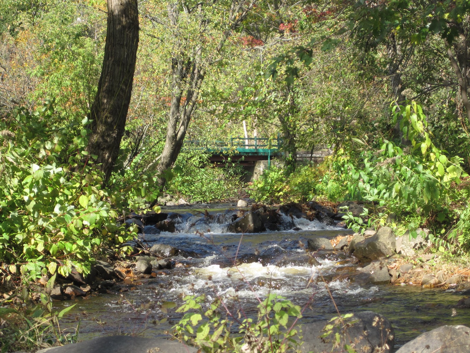
The river is cut in three sections here. Must be because of an old abandoned beaver dam which was engulfed by the vegetation.


Above: Being solo made me capable to not put my feet in the flat section of the tiny river ounce even in only a few inches of water. Of course I use my paddle more like a pushing stick in those situations.


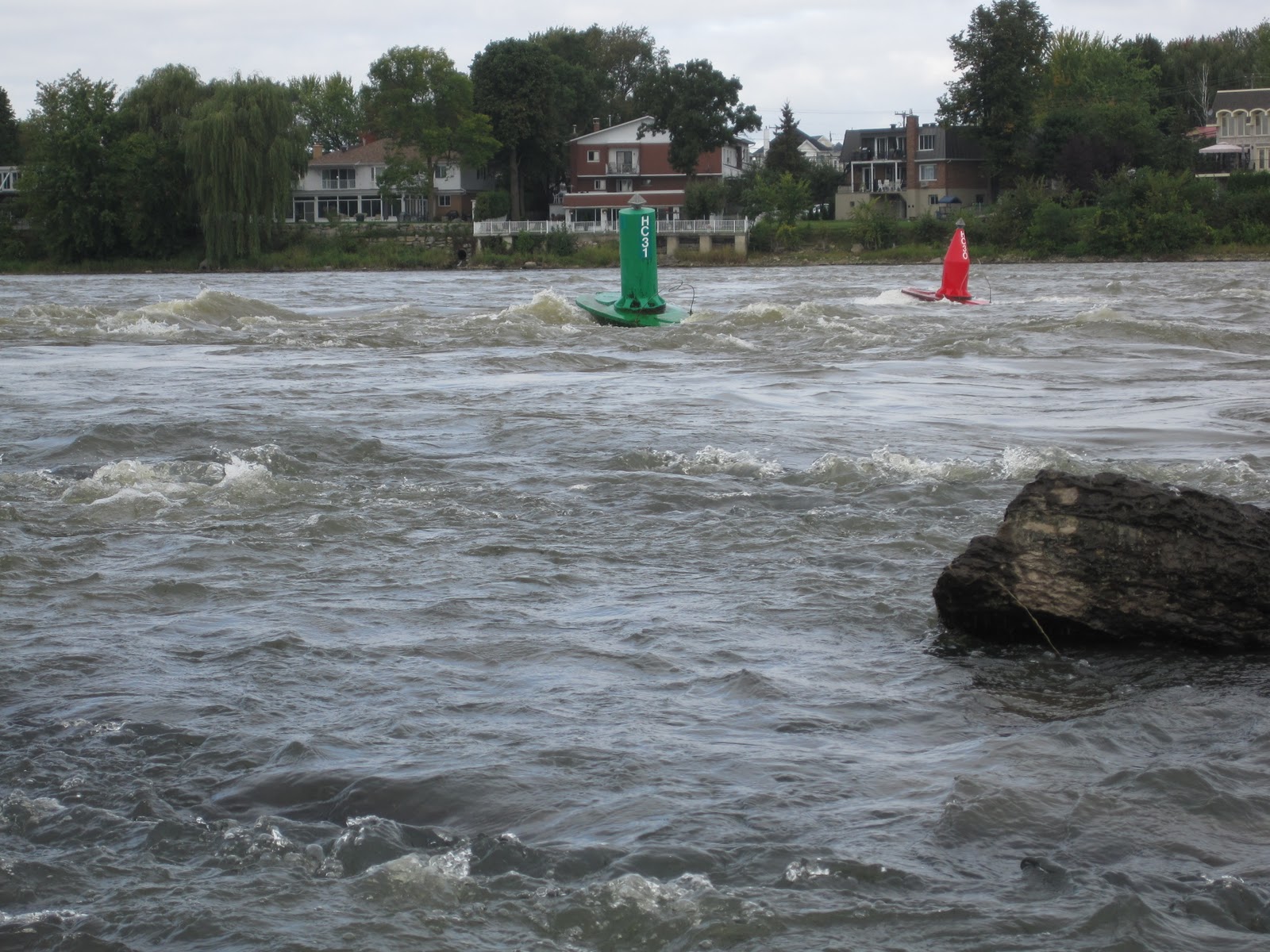
Above: This was expected at one point. Cant be flat for too long in the Laurentian mountains. But this was still a lot of fun. Very technical. No beaver dam (always a possibility, but are normally easily manageable by flash portage). Also, it always help to bring a small compact saw to saw your way into fallen and tangled branches found typically on those tiny rivers.


Thursday 13 October 2011

Canoeing the Du Nord river from St-Canut

Canoeing day was october 9th. Du Nord river (North river) is a primary tributary of the Ottawa river in Quebec. It ends in the Ottawa river around 30 km upstream Montreal island. The Du Nord river in St-Canut area as a small slope and therefore is fairly easy to paddle upstream. Despite being into an urban area, this section of the river has generally well preserved banks; not bad for a river section 30-40 min drive from downtown Montreal. To get access to canoe landing spot in St-Canut take highway 15 North from Montreal island. Then take St-Canut / route 158 exit (if you start climbing the Laurentian mountains you pasted the exit) . Take route 158 west toward St-Canut. Take St-Canut exit (around 5km from highway 15). Turn left on St-Canut boulevard (main street).  Turn right at Rita-Audet park just past the basketball field. You can go into the woods up to near the waterfront. Here are some pictures. Again since I was on my own, went upstream the river.


Above: Du Nord river section described in this blog. Color coded map is from canoeing association Fédération Québécoise du Canot-Camping


Above: Turn right at this sign on St-Canut boulevard for canoe landing.


Above: canoe landing spot. Upstream is on the right.


Above: Soon going upstream you will find that nice little R1. Little waves perfect to familiarize with canoe surfing. Passing the rapid with feet in the water over the rocks easy from the left side.


Above: Little island just upstream the rapid. Easier to paddle upstream on the right side.


Above: Tangle of logs and branches behind the island gives an idea of spring water levels.


Above: River banks has still a few of traditional decent size country houses.


Above: This traditional style country house respects the river high waters.


Above: The bridge of St-Canut.


Above: Little stream ending in Du Nord river on the left side of St-Canut bridge.


Above: Another little stream ending in the river on the left side of St-Canut bridge.


Above: The river banks on this section of the river is in general very well preserved.


Above: Minks are making a comeback in urban areas where rivers banks are decently conserved.


Above: Anywhere on river sections with low slopes you will find musk rats and their huts.

Sunday 25 September 2011

Des Prairies river canoeing from Montreal island

The Des Prairies river (Plains river) flows between Montreal and Laval islands. Montreal and Laval islands are the two largest islands of the Hochelaga archipelago (over 200 islands) created by the mixing of two great rivers that are the Ottawa and the St-Lawrence rivers. The western part of the Des Prairies river has honest currents with small stretches of white waters. Someone can do a fair distance upstream with a canoe that has a saddle or strapping gears. Thats what I did today which was september 25th. Canoe landing was possible from Roxboro island in the western part of Montreal Island. To get there take the Boulevard des Sources exit from highway 40 and drive north up to Gouin boulevard. Then turn right on Gouin then left 2-3 streets later on 5e Av. (5th avenue). Go to the end of 5e av. for parking. Parking allowed all day during weekend days but only from 9:00 am to 4:00 pm during week days. Here are some pictures from this canoe day.


Above: Des Prairies river section described in this blog. Color coded map is from canoeing association Fédération Québécoise du Canot-Camping


Above: the entrance of Roxboro island.


Above: you have to cross Roxboro island to reach the Des Prairies river. Portage from start of Roxboro island to the river is maybe 100 to 200 m. Landing of canoe directly on the left of the bridge will bring you to the river but in low water like today I needed to get out of the canoe 2-3 times to get over obstacles. Beware for your  white clothes, its muddy. Distance from bridge by canoe around 200 m.


Above: Upstream view of the Des Prairies river from Roxboro island. The Laval side in this area (across) is very residential while the Montreal island side in the Roxboro area (this side) is better conserved. A lot of ducks and geese observed on the Montreal island side. Went canoeing upstream. First stop was at the ridge where there is a bit of white water (at the end of the picture).


Above: The ridge goes from the Montreal island side to almost the other side (in Laval). White water at the end of the ridge towards Laval island is perfect for someone that wants to get familiar with wave surfing.


Above: Downstream view from the ridge. Mont-Royal in sight. Downtown Montreal is behind Mont-Royal in this picture.


Above: The Des Prairies river waterway passes on the right side of the ridge when coming upstream.


Above: To get more upstream on the river my paddling skills dont allow me to use the waterway like these guys (I am challenging anyone to try). Crossing the ridge with my feet in the water fairly easy. Paddling on the left side after crossing the ridge is much more easy to get more upstream.


Above: Train bridge crossing from Montreal island to Bigras island. This bridge is around 1 km upstream the ridge.


Above: Train bridge crossing to Bigras island again.


Above: Bridge pillars always a nice spot to rest when going upstream. Car bridge leading to Verte island (Green island). Went upstream toward that bridge and further up.


Above: Several houses around the islands in this area have their waterfront like fortress to protect their houses from spring high waters.


Above: The Des Prairies river is probably the biggest hydroplane hub in Quebec. When hanging on this river, you are almost always sure to see one either landing, taking off or being parked. This parked one was observed between Bizard and Bigras island. Thats the furthest upstream I went on the river.

Sunday 4 September 2011

Canoeing along the Long-Sault islands in Ontario

The Long-Sault islands are accessible by a parkway that crosses every islands sitting on the St-Lawrence river in a string-like fasion. It takes around 1 hr 15 min by car to get there from Montreal in the south-west direction. The parkway goes from Long-Sault to Ingelside on the north shore of the St-Lawrence river and crosses a dozen islands. The islands are part of some sort of a park (there is an entry fee) and allow all kinds of water sports including fishing and allow camping. Canoe landing is possible all over the islands. Long-Sault stands for Long Rapids but dont look for them they are gone. I think they got flooded when the St-Lawrence seaway was built in 1950s when the dam located in Cornwall was built. Some villages were also flooded and sacrificed for the seaway and that dramatic event is still palpable in this area (theatre events remembering the events, routes that goes directly into the St-Lawrence river, local people talking still about it etc). The islands are great for carp fishing  and are internationally known by the carp fishing community. It is possible to see schools of big carps hanging in shallow water in bays around the islands. Beware of islands sitting outside the Long-Sault string, they may be part of USA and if you decide to canoe around them you will be illegally crossing the US border (thats exactly what I did ounce). Contrary to Quebec, the section of the St-Lawrence river that crosses Ontario is divided in two with the US. Here are some pictures.


Above: One of several spots to land canoe on the Long-Sault islands.


Above: canadian geese are common on the Long-Sault islands.


Above: it is possible to rest on several different spots on the Long-Sault islands.


Above: no, these are not apple trees but hawthorns. Given there sizes they must be very old.


Above: typical Long-Sault island shallow water bay. If you canoe in these bay and you ear feet walking in the water but you dont see any human being: its a carp. If you ear some sucking noise but dont see anyone: its a carp sucking on water plants roots.


Above: wild lilies can be observed in shallow water of shady bays. These were observed from Croil island wich sits across the most western located of Long-Sault islands. These lilies could have put us into trouble since Croil island is on the US side of the St-Lawrence river. Croil island smells very good in june and nothing stop its scents to cross illegally into the Canadian side. 

Tuesday 23 August 2011

Canoeing St-Louis lake from Pointe-Claire

St-Louis lake is a St-Lawrence river enlargement on the south west side of Montreal island (see also other St-Louis lake blog april 2011). Pointe-Claire (Clear-Point) is a Montreal borough a few km west of downtown Montreal. St-Louis lake sits just upstream of the mighty Lachine rapids (see other blogs). Pointe-Claire is where the fur traders named Voyageurs (the Travelers) were leaving for there annual trip around Huron lake from april to november in large canoes called rabaska. Canoe landing is possible from the park at the end of Cartier street in Pointe-Claire (free parking). The area around the park is canoe friendly with minimal motor boats. There is a lot of sail boats,  and I think there is even a sailing school not far. You are almost assured to see one or two sturgeons jumping out of the water every time you go there. Here are some pictures (no sturgeons included, sorry).


Above: Circled area where canoe spot is. Colored code map is from canoeing association Fédération Québécoise de Canot-Camping


Above: west side view from the park. I think this is the historical Pointe-Claire. Further away we see part of Perrot island.


Above: closer view of the historical Pointe-Claire.


Above: south side view from the park in Pointe-Claire. Across somewhere is the town of Chatauguay where the river of the same name ends (see Chatauguay river blog).


Above: the church of Pointe-Claire I guess. It sits on the west side of the park.


Above: East side view from the park. Mount-Royal in sight. Left is University of Montreal, center there is St-Joseph oratory and right the tip of downtown Montreal highest buildings can be observed or guessed (for the not convinced).

Sunday 14 August 2011

Canoeing the Lachine rapids on the St-Lawrence river: section Lasalle part II

For introduction go to the july 2011 version 1 of this blog ''Canoeing the Lachine rapids on the St-Lawrence river: section Lasalle''. This time I parked near the river front across Douglas hospital on Lasalle Boulevard. There is a parking there free of charge.


Above: End of Lachine rapids is circled. Colored code map is from canoeing association Fédération Québécoise de Canot-Camping

Here is 3 pictures that will give someone an idea of the drop that represents the Lachine rapids and the following current which links St-Louis lake (a St-Lawrence river enlargement) to downtown Montreal.  The drop can be appreciated in terms of story levels of downtown Montreal highest buildings.


Above: view of downtown Montreal from Lac St-Louis. Only the top section of the highest buildings can be observed. The drop from St-Louis lake to downtown Montreal ground level is therefore probably around 20 to 30 story high.


Above: View of downtown Montreal from the bottom of the Lachine rapids. Still a fare number of story levels to go down before reaching downtown ground level.


Above: Downtown Montreal ground level.  These last 3 pictures gives a hint of the 3D nature of Montreal island. It would be awesome to have a complete 3D picture of Montreal island one day.
For old bridge fans, Victoria bridge can be observed here. At one point this bridge I think was the longest in the world (around 1875 I would say). Designed originally for trains, it now allows car as well and cargo can pass thanks to elevation of a section of the bridge without traffic interruption.

From Lasalle waterfront I went across toward the end of Heron island. Heron island cuts the Lachine rapids in two. The end of the island coincide more or less with the end of the rapids. Here are some pictures.


Above: View of Mont-Royal from the end of Heron island.


Above: Heron island is cut in two actually. The right section is actually named  Ile aux Chèvres (goat island) and the left section is the actual Heron island. But no one knows that (I learned this from Googlemap).


Above: Nice drop beside Rock island. Rock island is a tiny island someone can encounter just before crossing toward the end of Heron island. There is actually a little quay and a picnic table on this side of the island.


Above: view of some Heron island country houses from Rock island.


Above: upstream view of the Lachine rapids from Rock island. The real crazy action is where the tiny white line is far up. It must be unreal there with types of current unseen before. I consider the current around Rock island 5 to 10 times less violent then what is up there (observed with binocular of course when I was near that section on the waterfront one day) but still I have observed some pretty strange water current patterns around Rock island.

Now here are some picture of the Lachine rapids viewed from the other side of Heron island (the south side).


Above: A nice drop can also be observed a bit upstream from the end of Heron island.


Above: A violent rapid section is present near the south shore waterfront (tiny white lane further away).


Above: As for the north side of the Lachine rapids, the real action is much more upstream (white lane way upstream). I don't think I will ever try that section. The currents must be way to unpredictable and with currents that traps you.


Above: Small scale version of a bizarre current that the Lachine rapids I am sure can offer all over the place. Here I needed to paddle pretty hard after taking this picture to get out backward of the deceptively not that small counter current that can be observed closest to the camera.